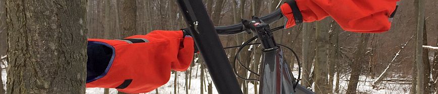

Hand Made in the Mitten

Maybury
Island Lake
Lakeshore (Novi)
Milford Trail
Wayne Co. (Hines Drive)
Highland Rec
Bald Mountan

Plea for Responsibility:
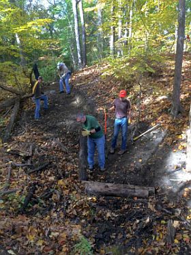
With the many new mountain bikers each year, the increased traffic can take its toll on the trails. IMBA affiliates like MCMBA, MMBA. have spent hundreds of hours building, and maintaining these trails for sustainability and fun. They ask only a few things to help keep these trails great for many years.
As riders we should share the burden and ride sensibly. Here are a few good etiquette tips for any mtb trail.
1.) Do not build, cut, or edit the existing trail
2.) Be aware of others on the trail by riding in control. Avoiding surprises to you or others.
3) Ride on the trail - Do not use short cuts.
4.) Be an Ambassador for the sport. Your actions good and bad reflect on the entire cycling community. If you see a new cyclist or someone disregarding trail etiquette, please politely mention it to them, or in worst case scenario report it to the park manager.
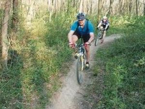
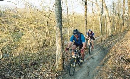
Maybury State Park is located just west of downtown Northville, mountain bikers have been enjoying the park for since the late 80'. The old trails used to be a combination of horse and hiking, and were non-directional adding a little extra excitement around blind corners. The climb up the back of the sled hill always made for leg burning experience, and added the bonus of going back down.
In the mid 90's the Michigan Mountain Bike Association (MMBA) become involved in the trail development and maintenance. The MMBA developed new trails and added signage to separated horse / pedestrian traffic and help avoid possible conflicts. The current trail is a combination of some old trails and the new trails which is about 6.5 mile long. The trail itself has a great rolling feel to it, but still makes you work for the top of each hill.
This is an excellent place for beginners and and novice riders to cut there teeth on some slightly tougher terrain. Expect some longer climbs, loose turns, roots, rocks, and small drop offs along the trail. Ride Smart! wear a helmet, ride with others, and if a section looks difficult, there is no shame in getting off and walking. While Maybury may get beginner and novice riders heart pumping, experts also love it for the speed and technical flow of the trail.
Season:
The trails are open all year with the exception of some closures during the spring thaw or muddy season. During the spring and summer you can expect mosquito’s and humidity in the summer. So drink lots of water, wear bright breathable clothing, bring BUG REPELLENT, and as Dr. Lisa always says "Wear Sunscreen".
Note: MCMBA asks that you don't use trails during wet weather or during spring thaw, this will damage the trails and hurt mountain bike / Land Manager relations.
Organizations:
Motor City Mountain Bike Association (MCMBA.org)
Trail Map:
http://site.mcmba.org/images/Maps/Maybury/maybury_map.pdf
Amenities
Maybury is a well maintained state park with running water in some areas, bathrooms and outhouses. The park also boasts playgrounds, pop machines, paved paths (bike, blade, walk), fishing, picnicking, and horseback riding. If you need supplies Northville is very close with a variety of shops, restaurants, and coffee shops.

Plea for Responsibility:
With the many new mountain bikers each year, the increased traffic can take its toll on the trails. IMBA affiliates like MCMBA, MMBA. have spent hundreds of hours building, and maintaining these trails for sustainability and fun. They ask only a few things to help keep these trails great for many years.
As riders we should share the burden and ride sensibly. Here are a few good etiquette tips for any mtb trail.
1.) Do not build, cut, or edit the existing trail
2.) Be aware of others on the trail by riding in control. Avoiding surprises to you or others.
3) Ride on the trail - Do not use short cuts.
4.) Be an Ambassador for the sport. Your actions good and bad reflect on the entire cycling community. If you see a new cyclist or someone disregarding trail etiquette, please politely mention it to them, or in worst case scenario report it to the park manager.
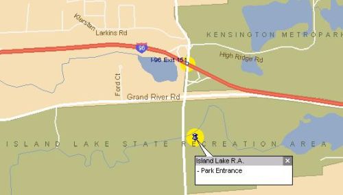
Island Lake State Recreation Area is located just West of Kensington Metropark. Near the US-23 / I-96 interchange. There are 2 beginner friendly trails available. Blue Loop which is 9+ miles, and Yellow Loop at 5 miles, but more elevation than Blue. These two loops can be ridden completely separate or combined quite easily. Both trails are relatively are very well marked (a large map is posted at the trail head parking lot). Mostly flat with gentle rolling grass lands and some medium length gradual climbs. This is one of the heaviest used trails in the area due to its proximity to the highway and easy to moderate skill level. More experienced riders will find these trails a great place for speed, or to bring there less technical riding friends.
Directions
From I-75: Take I-75 to I-696 and head West. I-696 turns into I-96 at the I-275 interchange. Continue on I-96 West for about 15 miles to the Kensington Road exit (exit 151). Head south on Kensington Road 1/4 mile past the light (Grand River Ave.) The park entrance is on left. Once in the park turn right at the booth and Follow the road to the 2nd right to get to the trail head parking lot.
From US-23: Take US-23 to I-96 and head East for 3.3 miles to the Kensington Road exit (exit 151). Head south on Kensington Road 1/4 mile past the light (Grand River Ave.) The park entrance is on left. Once in the park turn right at the booth and Follow the road to the 2nd right to get to the trail head parking lot.
Season:
The trails are open all year, with most riders staying off the during the spring thaw. During the spring and summer you can expect mosquito’s and humidity in the summer. So drink lots of water, wear bright breathable clothing, bring Bug Repellent, and as Dr. Lisa always says "Wear Sunscreen".
Note: MCMBA asks that you don't use trails during wet weather or during spring thaw, this will damage the trails and hurt mountain bike / Land Manager relations.
Organizations:
Motor City Mountain Bike Association (MCMBA.org)
Trail Map:
http://site.mcmba.org/images/Maps/IslandLake/Island_lake_map.pdf
Amenities
Paved parking lot, outhouses and a hand pump for water at the trail head. The road is frequented by road bikes as well as a nice destination. and can access Kensington Metropark via the Bike Path.

Plea for Responsibility:
With the many new mountain bikers each year, the increased traffic can take its toll on the trails. IMBA affiliates like MCMBA, MMBA. have spent hundreds of hours building, and maintaining these trails for sustainability and fun. They ask only a few things to help keep these trails great for many years.
As riders we should share the burden and ride sensibly. Here are a few good etiquette tips for any mtb trail.
1.) Do not build, cut, or edit the existing trail
2.) Be aware of others on the trail by riding in control. Avoiding surprises to you or others.
3) Ride on the trail - Do not use short cuts.
4.) Be an Ambassador for the sport. Your actions good and bad reflect on the entire cycling community. If you see a new cyclist or someone disregarding trail etiquette, please politely mention it to them, or in worst case scenario report it to the park manager.
Lakeshore Park (Treefarm)
Lakeshore Park is also known as the Tree Farm because it used to be a Christmas tree farm years and years ago. In fact parts of the trail (the pines section) ride through the old groves of spruce trees. The small parcel of 400 acres is host to a great weekly group ride and one of SE Michigan's biggest Mountain bike events...The Treefarm Relay.
The MTB trail crosses over some of the 2 track hiking/XC Skiing trails and is completely separate as single track. The trial has very low elevation overall, but the MCMBA crew maintain and built a flowing trail with optional features, and tight technical sections too.
Hunting is not permitted, making the Tree Farm a great place to ride in the fall and winter. Never really considered a technical trail it does have a few skinnies, and technical section that can be optional for any rider to avoid if they wish as well. Access is through Lakeshore Park, parking is free between Labor Day and Memorial Day. The rest of the year non-residents pay a small fee.
Directions:
From I-75: I-75 to I-696 and head West. I-696 turns into I-96 at the I-275 interchange. Follow I-96 west to exit 162 (Novi Road), head north on Novi Road 1.6 miles to traffic light at "Old Novi Road", turn left. Proceed 0.5 mile to South Lake Shore Drive, turn left, then 0.4 mile to Lakeshore Park on your left, The trail begins at the end of the dirt road where you'll see a Kiosk with updates and current maps. i
From US-23: US-23 to I-96 and head east to exit 162 (Novi Road), north on Novi Road 1.6 miles to traffic light at "Old Novi Road", turn left. Proceed 0.5 mile to South Lake Shore Drive, turn left, then 0.4 mile to Lakeshore Park on your left, The trail begins at the end of the dirt road where you'll see a Kiosk with updates and current maps. i
Season:
The trails are open all year with the exception of some closures during the spring thaw or muddy season. During the spring and summer you can expect mosquito’s and humidity in the summer. So drink lots of water, wear bright breathable clothing, bring BUG REPELLENT, and as Dr. Lisa always says "Wear Sunscreen".
Note: MCMBA asks that you don't use trails during wet weather or during spring thaw, this will damage the trails and hurt mountain bike / Land Manager relations.
Organizations:
Motor City Mountain Bike Association (MCMBA.org)
Trail Map:
http://site.mcmba.org/images/Maps/Lakeshore/Map-LakeshorePark.pdf
Amenities
Bathrooms with running water are open during the regular season. a small beach is also in the park for an after ride dip. A very well maintained trail and park also boasts playgrounds, soccer field, and shelters for picnicking.
Plea for Responsibility:
With the many new mountain bikers each year, the increased traffic can take its toll on the trails. IMBA affiliates like MCMBA, MMBA. have spent hundreds of hours building, and maintaining these trails for sustainability and fun. They ask only a few things to help keep these trails great for many years.
As riders we should share the burden and ride sensibly. Here are a few good etiquette tips for any mtb trail.
1.) Do not build, cut, or edit the existing trail
2.) Be aware of others on the trail by riding in control. Avoiding surprises to you or others.
3) Ride on the trail - Do not use short cuts.
4.) Be an Ambassador for the sport. Your actions good and bad reflect on the entire cycling community. If you see a new cyclist or someone disregarding trail etiquette, please politely mention it to them, or in worst case scenario report it to the park manager.
Season:
The trails are open all year with the exception of some closures during the spring thaw or muddy season. During the spring and summer you can expect mosquito’s and humidity in the summer. So drink lots of water, wear bright breathable clothing, bring BUG REPELLENT, and as Dr. Lisa always says "Wear Sunscreen".
Note: MCMBA asks that you don't use trails during wet weather or during spring thaw, this will damage the trails and hurt mountain bike / Land Manager relations.
Organizations:
Motor City Mountain Bike Association (MCMBA.org)
Trail Map:
http://site.mcmba.org/images/Maps/Milford/MilfordMtBikeTrailmap.pdf
Amenities
Milford is right outside Downtown Milford. While the par has no amenities on site, it is easy to get to the downtown from the trail or on the way to the trail. Many people actually park in downtown and ride to the trails. Plenty of restaruants, brs, coffee, and
Plea for Responsibility:
With the many new mountain bikers each year, the increased traffic can take its toll on the trails. IMBA affiliates like MCMBA, MMBA. have spent hundreds of hours building, and maintaining these trails for sustainability and fun. They ask only a few things to help keep these trails great for many years.
As riders we should share the burden and ride sensibly. Here are a few good etiquette tips for any mtb trail.
1.) Do not build, cut, or edit the existing trail
2.) Be aware of others on the trail by riding in control. Avoiding surprises to you or others.
3) Ride on the trail - Do not use short cuts.
4.) Be an Ambassador for the sport. Your actions good and bad reflect on the entire cycling community. If you see a new cyclist or someone disregarding trail etiquette, please politely mention it to them, or in worst case scenario report it to the park manager.
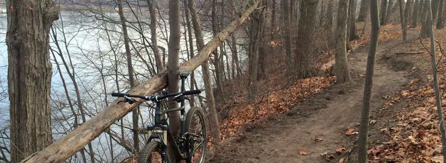
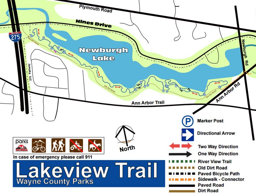
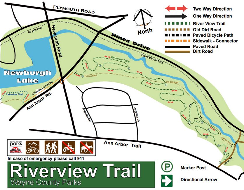
Wayne Co Trails (aka Hines Drive Trails) Hines Parkway is the home to our newest trails in SE Michigan in partnership with Wayne County and MCMBA. The trail currently has 2 segments Lakeview and Riverview. This trail follows Hines Drive along the Middle Rouge River, with 15 miles of heavily used paved pathways connecting cyclists in the surrounding communities. These mountain bike and hiking trails inviting users away from the road and into a natural singletrack experience. Two segments have been completed, each with their own unique character:
Lakeview Trail is a 2.5-3.0 miles trail follows the south shoreline of Newburgh lake. This segment is highlighted by breathtaking views of the lake as the trail twists, climbs and descends along the steep overlooking bluffs.
Riverview Trail is a 1+ mile trail that continues east of Newburgh, providing more up close and personal encounters with the Rouge River mixed with meadows and hardwood forests.
The Hines Park mountain bike trails are a combination of One way AND Two way trails. They are also Multi-User friendly so please ride with caution and be prepared to yield to other users and oncoming traffic.
Season:
The trails are open all year with the exception of some closures during the spring thaw or muddy season. During the spring and summer you can expect mosquito’s and humidity in the summer. So drink lots of water, wear bright breathable clothing, bring BUG REPELLENT, and as Dr. Lisa always says "Wear Sunscreen".
Note: MCMBA asks that you don't use trails during wet weather or during spring thaw, this will damage the trails and hurt mountain bike / Land Manager relations.
Organizations:
Motor City Mountain Bike Association (MCMBA.org)
Amenities
Hines trails are accessible from many points and are unique as it winds through several communities. Hines Drive itself has several comfort stations which are open during the normal season, and closed during winter months. But there are plenty businesses to start from or visit mid ride.

Directions
From I-75: Take I-75 to M-59, Take M-59 West (Head past Pontiac), about 15 miles to Duck Lake Rd in White Lake Township. Turn left (South) onto Duck Lake for about one mile. Turn right onto Livingston Road, drive a ver short distance to the small trailhead parking lot (small dirt lot). The lot is on your right (North side of Rd), and the trail is directly across the road.
From US-23: Take US-23 to M-59, Take M-59 East to Duck Lake Rd in White Lake Township (approx. 6 mi.). Turn right (South) onto Duck Lake for about one mile. Turn right onto Livingston Road, Same as above directions.
Plea for Responsibility:
With the many new mountain bikers each year, the increased traffic can take its toll on the trails. IMBA affiliates like MCMBA, MMBA. have spent hundreds of hours building, and maintaining these trails for sustainability and fun. They ask only a few things to help keep these trails great for many years.
As riders we should share the burden and ride sensibly. Here are a few good etiquette tips for any mtb trail.
1.) Do not build, cut, or edit the existing trail
2.) Be aware of others on the trail by riding in control. Avoiding surprises to you or others.
3) Ride on the trail - Do not use short cuts.
4.) Be an Ambassador for the sport. Your actions good and bad reflect on the entire cycling community. If you see a new cyclist or someone disregarding trail etiquette, please politely mention it to them, or in worst case scenario report it to the park manager.
Highland State Recreation Area
State Recreation Area is about 15 miles west of Pontiac, off M-59. One of the newer trails in lower Southeast Michigan, It was designed and built as a handling challenge. This trail is 100% single track with many gradual climbs and descents. It is very difficult to sustain any speed because of the technical and tight nature of this trail. You will find off camber sections, roots, rocks, logs, etc.
With the technical nature of this course you will have find the repetition of Brake, Shift, Turn, repeat will make you mentally exhausted and fatigue your entire body. By the time you reach the D loop you will be listing names of people to sell your bike to...and wondering how much further till its over. Once you finish the reward will settle in as you reminisce with pals about a near death experiences, and cleaning seemingly impassable sections. You will look at it as a challenge to for the next time, The entire trail will take 2 ½ - 3 hours so bring plenty of water and food.
There are NO provisions for water here, bring what you will require and then some. There are 4 loops you can attempt/ See Trail Description below.
This is definitely not a beginner course and should not be ridden alone or after dusk with out a lighting system. Keep in mind if you have a mechanical or are just too weak and sickly to finish, there is only one bail out spot located off C Loop. Realistically once on the trail the only way back is forward, the best you can do is find your way back to A loop and return. The state does require a parking permit, if you need one they can be purchased by filling out the envelope (with money) and placing it in the daily registration canister.
Trail Description
Highland State Rec. Area is one of the ore technical trails in Southeast Michigan. The design was originally built to control speed and provide reward to riders with good technique and balance. Every time I go I get mentally tried, rather than physically tired. The course constantly requires action and reaction, to maintain balance. The hills are all very climbable, the terrain a little rough but compact. There are only a few sections which I consider impasse, the rock garden climb in D, and the occasional downed tree. Be sure to watch for low tree limbs as well as the trail obstacle course. The rest of the trail is slow paced handling fun. You have your choice of riding difficulty and distance, from 3.8 to 16 miles. all are trails linked together Via A and B. you can ride them all or pass on the tough ones.
There are 4 distinct loops at Highalnd. Complete A,B,C, and D, for a total of 16 miles. Everyon starts on A loop then has the opportunity to to m0re loops at the B intersection. Both B and D connect to/from the A Loop. C loop is accessed only from the B loop.
A Loop = 3.8 miles, intermediate or expert rider level.
B Loop = 5.9 miles, intermediate or expert rider level.
C Loop = 2.4miles, accessed from the B loop.
D Loop = 3.2 miles, accessed near the end of the A loop.
Season:
The trails are open all year with the exception of some closures during the spring thaw or muddy season. During the spring and summer you can expect mosquito’s and humidity in the summer. So drink lots of water, wear bright breathable clothing, bring BUG REPELLENT, and as Dr. Lisa always says "Wear Sunscreen".
Note: MCMBA asks that you don't use trails during wet weather or during spring thaw, this will damage the trails and hurt mountain bike / Land Manager relations.
Organizations:
Motor City Mountain Bike Association (MCMBA.org)
Trail Map:
http://site.mcmba.org/images/Maps/Highland/Highland-MMBA.pdf
Amenities
Highland State Rec has an Outhouse and a Dirt parking lot. However you are close to M-59 snd close to Milford too. for after ride feasts.
Trail Map
Plea for Responsibility:
With the many new mountain bikers each year, the increased traffic can take its toll on the trails. IMBA affiliates like MCMBA, MMBA. have spent hundreds of hours building, and maintaining these trails for sustainability and fun. They ask only a few things to help keep these trails great for many years.
As riders we should share the burden and ride sensibly. Here are a few good etiquette tips for any mtb trail.
1.) Do not build, cut, or edit the existing trail
2.) Be aware of others on the trail by riding in control. Avoiding surprises to you or others.
3) Ride on the trail - Do not use short cuts.
4.) Be an Ambassador for the sport. Your actions good and bad reflect on the entire cycling community. If you see a new cyclist or someone disregarding trail etiquette, please politely mention it to them, or in worst case scenario report it to the park manager.
Other Activities:
Bald Mountain is also known for cross-country skiing, snowmobiling, sledding, and ice fishing. 8 miles of groomed trails for X-country skiing. 7 additional miles of trails and 3,000 acres, are available to snowmobiles. Bald Mountain also features a large sledding hills.
A nice fall color hike through t the scenic 4,637 acres. A stop at one of the cider mills nearby is always a nice finish to the day.
Hunting: Approximately 3,500 acres in Bald Mountain Recreation Area are open to hunting. Hunter safety courses are taught at the shooting range each fall.
Boating & Fishing: Small boating and canoing are all popular activities on Bald Mountain's 11 different lakes. Anglers will find pan fish, northern pike, and largemouth bass in all these lake.
Rustic Cabins Two rustic cabins are located on Tamarack Lake and are located adjacent to eight miles of hiking, biking, and cross-country skiing trails. Each cabin has space for up to 20 occupants.
Contact:
Bald Mountain State Park
1330 Greenshield Rt. 1
Lake Orion, MI 48360
Phone # (810) 693-6767
TDD #(517) 335-4623
Bald Mountain State Recreation Area (North Unit) Is located near Lake Orion, just west of Rochester, MI. The North unit offers 2 smaller loops which total 8 miles of fun wide trail riding. The trail is great for beginners through expert riders, with a few challenging hills (both up and down), semi-technical riding, and the occasional roots. The North unit is mainly a wide version of a single track trail which allows you to carry a good amount of speed through it. Please be courteous of other trail users as this park is also enjoyed by hikers, bird watchers, fishermen and hunters.
This trail is also directional! Follow the numbered signs and obey any trail closures. In the event you need to back track, please be cautions or walk your bike. There is also plenty of scenery while weaving through the rolling terrain.
Completing both loops of the North trail can take 1-2 hours, bring plenty of water, food and supplies. The state does require a parking permit, if you do not have a seasonal pass, you must purchase a daily permit by filling out the envelope, adding money, and deposit it into the self registration canister.
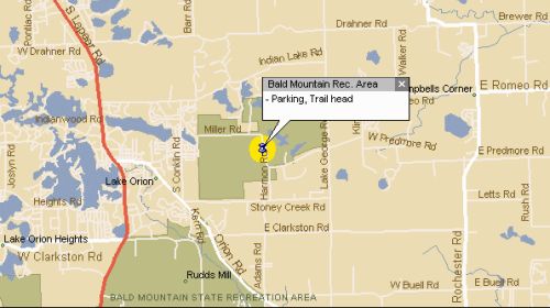
Directions to Bald Mountain North Unit
From I-75 : I-75 to exit 81 (Lapeer Rd. exit), same exit as for the Palace of Auburn Hills. Head North on Lapeer Rd. turning right (East) on Orion Road. Follow Orion a few miles and turn left (east) on Stony Creek Rd. Continue on Stony Creek Rd. for a mile or so, just past Adams to Harmon Road, turn left onto Harmon (Note: Harmon is a dirt road which you can only turn left onto). Just a short distance down Harmon you will come to the intersection of Predmore and Harmon...look to your left and notice the large dirt parking area.
Season:
The trails are open all year with the exception of some closures during the spring thaw or muddy season. During the spring and summer you can expect mosquito’s and humidity in the summer. So drink lots of water, wear bright breathable clothing, bring BUG REPELLENT, and as Dr. Lisa always says "Wear Sunscreen".
Note: MCMBA asks that you don't use trails during wet weather or during spring thaw, this will damage the trails and hurt mountain bike / Land Manager relations.
Organizations:
Motor City Mountain Bike Association (CRAMBA.org)
Trail Map:
http://www.cramba.org/storage/maps/baldmountain/CRAMBA_Bald_Mountain_North_05-Jan-2014.pdf
Amenities
There is absolutely NO WATER available, on the trail or in the parking area. An outhouses can be found shortly after you cross the last bridge and pass behind the ranger's house by the lake, and shortly after beginning the trail (from Harmon Parking lot). And head down a straight hill, up and left are the cabins and an outhouse.
Copyright Moose Mitts LLC 2016